_300x225.webp)
_300x225.webp)
_300x225.webp)
_300x225.webp)
_300x225.webp)
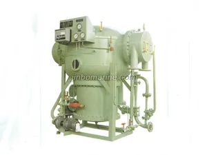
Marine Equipment
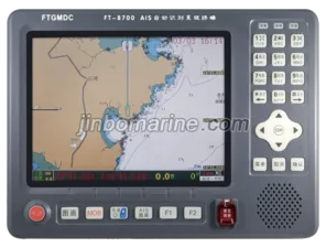
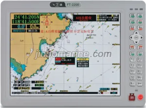
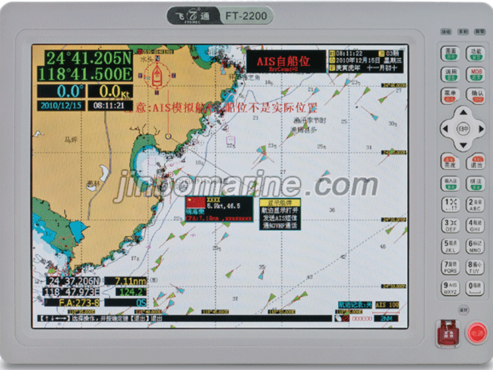
AIS Class-B (12.1-inch)
AIS Class-B (12.1-inch) (1). Main function introduced 1.Automatic Identification System (AIS) function Be able to the continuous autonomous receive and transmit...
Loading product images...

 PDF Datasheet
AIS Class-B (12.1-inch)
(1). Main function introduced
1.Automatic Identification System (AIS) function
Be able to the continuous autonomous receive and transmit the AIS data information;
Can display AIS data around own ship when ships equipped with AIS equipment
Static data include: MMSI, vessel name, call sign, IMO number, type of ship,
The size of the vessel, the GPS antenna position, Flag, etc.
Dynamic data include: latitude and longitude, speed, heading, rate of turn , azimuth, distance;
Navigation data, including: condition of navigation, ship' draft, dangerous cargo,destination and estimated time of arrival
When AIS target ship enter pre-setting range ,visual and audio alarm occur ,according to range varying sound changing
Send and receive emergency information by Chinese or English
AIS fleet management, AIS ship against alarm and found the ship list of alarms set;
AIS target ship's basic data display (ship name , id no , flag…..etc.)、tracking record
2.AIS target Approaching, sound (audio) and light (visual) alarm function
Distance alarm : When AIS ship enter within setting range of own ship, sound and light alarms will start
CPA alarm: When AIS ship enter TCPA, DCPA's alert setting area , sound and light alarm will start .
Note: while alarming, AIS targets on the screen turns red icon, flashing alarm indicator on the front panel,
At the same time speaker alarming tone: "The direction × × degrees apart × × nautical target Approaching
Careful avoidance."
3.Target ship information display function
List of showing the target ship (range, azimuth and 9 ID)
Target ship can display on Radar chart (display range of 1-128 nautical miles)
Target ship can display on Electronic chart
4.GPS navigation function
Can display the coastline of the country charts, the Geographic Names ,river map, and beacon lights , dangerous object
Ship's position, speed, heading ,course, track, time, date, and fishing areas display;
Beacon lights, hazardous materials increased add-on editing features;
Cursor position can read tides, port information, calendar, satellite images show the function;
Waypoint marker points, routes, track line storage and call
Can store up to 8000 waypoints, 10,000 mark point, 1000 route 100 000 track points
Cursor, waypoints, routes, track line navigation functions;
Destination position, distance and estimated time arrival display
Has arrived, course deviated , and take the anchor, speeding, route steering, the bridge alarm and prompted
(2).Technical specifications
1.
Main unit :
RF unit : 1 Transmitter, 2 TDMA Receivers
Frequency Range : 156.025-162.025MHz
Channel spacing : 25KHz
The Default Channels : A: 161.975MHz, B: 162.025MHz, DSC: 156.525MHz
Modulation method : GMSK9600b / s, FSK1200B / s (± 50ppm)
Frequency tolerance : ± 500Hz
Display screen : TFT color 12.1 inch LCD screen
Operating mode : CSTDMA / SOTDMA
Compass Distance : 0.8m
Power Supply : DC :9-16V / 3A or 9-38V/3A (option)
Protection class : IP45
Display resolution : 800 * 600 TFT color LCD
Data Interface : 4800 bps , 38400 bps, RS-232 / RS-422/TTL (three inputs, three outputs)
RF socket : 50Ω (VHF) , BNC 50Ω (GPS)
Audio power output : ≤ 5W / 8Ω (adjustable)
Operating Temperature : -20 ℃ ~ +60 ℃
2.
AIS Transmitter section :
Carrier power : 33dBm ± 1.5dB
Modulation spectrum:<- 25dBw
<- 60dBw
Modulation accuracy:<3400Hz(Bit 0,1)
2400Hz ± 480Hz(Bit 2,3 )
2400Hz ± 240Hz(Bit format 4-199 or 00001111 Bit format )
1740Hz ± 175Hz(0101 Bit format)
Power on the characteristics of the time : the transmit delay : 2083us
The ramp-up:≤313us
Ramp-down:≤313us
Transmit long:≤23333us
Spurious emission:<-36dBm(9KHz-1GHz)
<-30dBm(1GHz-4GHz)
3. AIS Receiver section
Reference sensitivity :-115dBm (package error rate of less than 20%)
High input tolerance : -77dBm (package error rate <2%)
-7dBm(Packet error rate <10%)
Co- channel interference : > 10dB (package error rate <20%)
Adjacent channel selectivity : > 70dB (package error rate of less than 20%)
Spurious response interference : > 70dB (package error rate of less than 20%)
Intermodulation response interference : > 65dB (package error rate of less than 20%)
Blocking : > 78dB (package error rate of less than 20%)
>86dB(Package error rate <20%)
Spurious emission : <-57dBm (1GHz ~~ 4GHz)
<-47dBm(9KHz~1GHz)
4.GPS section
Receiving frequency : L1 : 1575.42 MHz
Sensitivity : ≤-150dBm
Data update : once per second
Positioning errors : 2.5m
Positioning time : Cold start : < 60s , Hot start : < 1s
Note: Specifications are subject to change without notice.