_300x225.webp)

_300x225.webp)
_300x225.webp)
_300x225.webp)
_300x225.webp)
Marine Equipment
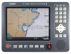
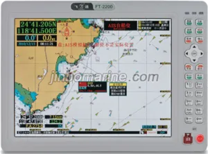
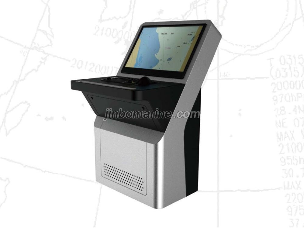
HLD-ECDIS60 Electronic Chart Display And Information System
HLD-ECDIS 600 is fully developed by our' s own advanced technology. The product fully meetsthe requirements of IMO standard and the latest IEC standards, approved by CCS and the Norwaycla...

HLD-ECDIS60 Electronic Chart Display And Information System
 PDF Datasheet
We can supply according to your requirement.
China HLD-ECDIS60 Electronic Chart Display And Information System:
HLD-ECDIS 600 is fully developed by our' s own advanced technology. The product fully meetsthe requirements of IMO standard and the latest IEC standards, approved by CCS and the Norwayclassification society DNV-GL A prototype of the system has experienced of validation in the marketto ensure the convenient use, stable and reliable, powerful. The product supports Chinese / Englishswitch, chart data update online, radar overlay, track control etc.. The system can be composed of adouble workstation, also can be used as a part ofINS.
Features:
Chinese/ English switchProvide Chinese/ English switchfunction,Chinese display interface ismore friendly.
Track control
Track Control is available by connecting to the Steering Control System from Highlander so that the sailor could do more tasksbesides frequent rudder adjustment.
ENC update on line
ENC update not only can be implemented locally, but also the ENC update can be finished online,by addressing the data sever in us and downloading the ENC updates.
Radar echo and ARPA overlay
Our Radar overlay is supplied directly based on LAN.For other manufacturers’radar, Extractor Radar Acquisition PCI Boardadapter is needed for echo overlay, ARPA targets can be displayed on Charts based on TTD or TTM sentence.
Weather routing
Provide weather data loading and displayfunction,Route generation based on the departure port and destination,and route optimiza'tion based on weather data and optimization index (short time short distance or lower energy),can supply the weather forecast date ofChina and France to ship owner, to assist the sailor to make the decision of navigation route.
NAVTEX management
Receive and display NAVTEX message, some filter criteria are available. For some specia NAVTEX message, ike military exercise area orwreck, the exact position of objects will be drawn on charts.
Chart data display
Support lHO -57, S-63 formats of electronic chart, can supply the ENC date of UKHO AVCS, PRIMAR,CNHO, China MSA, China CwB
( Yangtze River), etc.to ship owner,global data coverage.
Friendly interface
Integrated information display is convenient for the user at any time to observe and set the control parameters; provide EnglishChinese switching function; support 19",23", 24 "and 26" and other dimensions of maritime special industrial LCD monitors
Good training system
To meet the requirements of the latest STCW convention, can be in the sea he believed in office and engineering agency to attendtraining, also can be authorized by the owner training center to participate in training, but also by the sea he believed in onlineeducation system for training.
Basic functions
Chart showing : Course up or North up; different layers showing the chart information.Route Planning Task : Ability to calculate the distance and bearing between any 2waypoints, vessel position, track error, etc.
Chart Data Correction : Accepts official chart data update automatically or via user'sdownload, with automatic or manual correction.
Position Fix & Navigation : Receives and process navigational sensors data,providingconsistent reference position, track, heading, speed, etc, with various land reference for position fixing.
Voyage information acquirement : get the information including the description of the objects and the marine condition ,ex.meteor logical, tide, and the Ocean current.
Radar overlaying : Radar sinals overlay on the chart display for navigation and collision avoidance function. correlation betweenmoving and fixed targetsnavigator can assess collision risk and taking collisjon avoidance decisions and actions test trial collision
avoidance decisions.
Route Monitoring : automatic calculation of ship offset current state and plan routes when sailing, alert in necessary conditionautomatic detection of dangerous sea, reef and so on, to realize the collision avoidance and Stranded prevention.
Voyage recording : ECDIS will record and playback the 12 hours tracking information(include the time, vessel location, headingspeed, chart source, version and so on)every 1 min.
Specific functions
LOP data can be presented both alphanumerically and graphically
BACK UP two workstations are mutual backup function
NAVTEX message management and display
TCS track control(Optional)
Conning integrated navigation information display system (Optional)
RDS route decision support (Optional)